One of the most useful sources of data with regards to dating a marine deposit are layers of volcanic ash or tephra. Often these can be dated directly, or chemically fingerprinted and matched to a parent body of igneous rock.
In the case of the Purisima Formation, some portions of it have more ash layers than others; Chuck Powell at the Menlo Park USGS tells me the section where this photo was taken has 13 different ash beds.
This ash bed in particular has been correlated with the Putah Tuff Member of the Tehama and Tuscan Formations of Northern California. The Putah Tuff is approximately 3.4 +/- 0.1 Ma, based on radiometric dating.
The problem with finding and utilizing tephra in the first place for dating or for tephrochronology of course is whether or not it gets preserved in the rock record. Ash forms before an eruption as bubbles form near the opening of a volcanic vent during the release of gas prior to an eruption; the magma that forms the material surrounding the gas cools and mineralizes. This mineralized material forming minute walls between gas bubbles then fragments as the eruption continues, and due to the small size (ash is classified by igneous petrologists and volcanologists as being >2mm) these fragments are then carried into the atmosphere via a 'current' of heated air before and during the eruption. Ash can stay in the atmosphere for long periods of time, and can even travel around the globe. Ash beds chemically identical to Yellowstone's Huckleberry Ridge Tuff (2.2 Ma) have been discovered in deep sea cores from the Northeastern Pacific Ocean. Since ash blows with the
prevailing wind direction, and the prevailing winds in North America are westerlies, the ash apparently traveled around the earth (if anyone, e.g. Jeanette, has a reference for circumglobal ash deposition, let me know).
Typically, quieter ocean waters preserve ash better, as the ash needs to fall to the ocean surface, and settle to the sediment-water interface. High energy environments on the continental shelf rework sediment too rapidly to preserve discrete ash beds. However, there is also problem with depositing ash below storm- and fair-weather wave base: bioturbation.
Ah, those pesky critters geologists never like to pay much attention to - you know,
animals. Well, in this case, geologists will probably like them even less. The problem is that below storm- and fair-weather wave base, bioturbation is insane - in some cases, like in the Purisima Formation, bioturbators effectively completely homogenize the sediment; I would estimate (based on ichnofabric index) that the sediments in these strata have bioturbated over 95% of the sediment, at least as preserved in a 6 km section of cliffs, which are 100-250' high; I'm too lazy to do the math, but that is a real shit load of sediment to churn through - and thats just in 2D - I don't even want to imagine what the actual volume of bioturbated sediment would be.
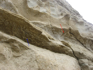
In the photograph I've posted (finally), you can see the Putah Tuff correlative ash bed. However, there's a twist - below the bed are the trace fossil
Ophiomorpha nodosa, which invade sediments below the ash bed (Blue Arrow). These burrows are infilled with ash, and appear white on a brownish sandstone background. More
Ophiomorpha nodosa invade the top of the ash bed, but are infilled with brownish sand(Red Arrow); again, there is beautiful contrast here with the brown filled burrows invading white ash.
In any event, those dastardly crustaceans weren't crafty enough to completely bioturbate the ash bed; the ash deposit was most likely too thick to be completely reworked. In all likelihood there is some sort of a preservational cutoff of ash thickness, although this would scale to the effectiveness of the bioturbating regime to homogenize sediment.
Fortunately, ichnofossils are extremely useful for paleoenvironmental reconstructions, so at least there is some information for geologists - not just a bunch of damn invertebrates destroying perfectly good sedimentary structures and ash layers.
P.s. I think I have a much better photo exemplifying this neat sand/ash contrast on a bioturbated contact; if I find it, I will post that as well).

 Above is part of a very thin ash bed (8-30cm thick - the ligher colored sediment) that has almost been destroyed by bioturbators (by the way, bioturbation is the disruption of primary sedimentary fabric by burrowing organisms/infauna). In fact, for most of its exposure it has been pierced by burrows (where the ash has been displaced into the burrow fill) that it looks like a dotted line. Above shows a U-shaped burrow; I can't remember what taxon this is - because some of them (i.e. Diplocraterion?) are defined based on spreiten (laminae within the burrow) inside the 'U'.
 Here yu can see how little of the original bed is left; much of the ash has been introduced as burrow fill, and mixed and diluted with regular sediment (fine-very fine silty sandstone in this case), hence the blotches looking slightly less 'pure' than the primary ash.
 A couple hundred feet away this bed thickens and isn't completely chewed up by bioturbation, enough so that you can see original sedimentary fabric within. In this case, it is a mix of swaley cross stratification (a small-scale version of hummocky cross stratification) and climbing ripples. Both of these sedimentary structures indicate uni- or bi-directional flow with a relatively high rate of sedimentation, i.e. sediment is just dumping out of suspension. This can happen during hyperpycnal flow - often occuring as a dense plume of sediment rich water introduced into the ocean from a river mouth, say after a big storm.
 This ash bed, on the other hand, is huge. There's a reason I don't have a scale bar; this is about a 5-10 meter thick ash bed. This has a completely different set of weird features - some pretty incredible soft sediment deformation. These look like giant scale ball and pillow or loading structures.
 This cliff right here is about 200 feet high, and we're looking at about 1/3 of it or so. These S.S.D. features continue for the entire outcrop length of this bed. The thinner ash bed featured above is visible in the very bottom of this photograph. The intense loading features here could, of course, be caused by a relatively rapid influx of a LOT of ash to the seafloor, which could lead to liquefaction of more typical sediment at the former (i.e. pre eruption) sediment-water interface (i.e. sea bottom), and leading to the big pillow-like lobes of ash, and the long upward pointing 'fingers' of sand.


