Friday, December 19, 2008

Thanksgiving Field Highlights


Ahh, this is why I love California. Especially my master's thesis field area. These are some tidepools exposed during a minus tide at sunset; Monterey Bay is the body of water to the left of the picture.

Yes... I'll use this to gloat about the election more. I'm happy the denizens of Capitola are happy about it to. You can actually see this paint job on photographs taken from aircraft:http://www.californiacoastline.org/cgi-bin/image.cgi?image=200810789&mode=big&lastmode=sequential&flags=9&year=current
Look at the base of the wall about midphoto, at the left end of the long lawn in the middle of the picture. I love the sunglasses that were added.

Here were some very odd linear features in the wavecut platform, which is an exposure of the Purisima Formation. Linear features such as this have been documented before in a similarly aged sedimentary unit of similar composition, the St. George Formation of Crescent City, in northernmost California. However, there the features were attributed to tsunami scouring by the transport of large boulders up and down the beach, in a direction normal to the shoreline. That is a north facing coast at Crescent City, and was susceptible to tsunamis from earthquakes in Alaska. However, this shoreline at Capitola, CA, faces south; what caused these features will likely remain an enigma.


Here is an atlas vertebra of a small mysticete whale preserved in the Purisima Formation. The atlas is somewhat similar to Piscobalaena and Herpetocetus, and likely belongs to the latter or a similar whale.

Monday, December 15, 2008

I have successfully navigated, conquered, and left the seventh level of hell

As in my first semester of graduate school, which was pretty damn tough, but a challenge nonetheless. In any event, finals are over, and my first real break from it has started... I... don't know what to do with all my free time! Its amazing... Anyway, expect more activity on here than what has been recently.

Happy finals!

Tuesday, November 25, 2008

Turkey Day!!!

Well, I'm about to leave for Thanksgiving week, and in a few minutes I'll be driving to the sprawling, gigantic Gallatin Field airport here in Bozeman (or should I say Belgrade). Anyway, it only has four gates, and can't service anything larger than a 737 (which it only does during the holidays).

I am super excited, mainly to see my family (who I haven't seen in several months), but also because of fieldwork - I have checked aerial photos, and there has been a LOT of coastal erosion, and it will only get worse (or in my case, better) between now and winter break.

You see, most paleontologists (here at MSU anyway) only get to their field areas in the summer, because its usually too damn cold to do so in the winter (although with a few Miocene land mammal spots around Bozeman, we've gone out in 20 degree weather before, and done jackets in 35 degree weather, with snow on the ground - we were really, really bored.... yeah...).

However, in California, it rarely dips below 45 degrees on the coast (and sometimes rarely above 55 in the winter), so it is possible to go out during this time of the year. However, in the winter, it is not only possible, it is usually far more productive as well. This is due to increased storm activity during the winter, and the increased chance of having cliff collapses (which really suck for the landowners above, who usually have pieces of their backyard now fifty feet lower, but is really good for me!). Also, during the summer the lack of extremely high tides and storms usually allows the cliffs to collect all sorts of dust, grime, and algae - storms during the winter usually clean off all this unsightly garbage, so that you can see clean, unweathered rock surfaces. I cannot begin to explain how much easier and more productive it makes collecting.

It also allows for the researcher to actually see sedimentary structures, and the detail of trace fossils (e.g. spreiten). Anyway, I have a good feeling about thanksgiving break, and a good feeling about winter break this year. Although I have no idea how I can top last winter break - a 40% complete fur seal skeleton (with partial skull), two partial odontocete skulls (one with partial skeleton, and a partial dentary), a 6" long Carcharocles megalodon tooth (aka bigass shark tooth), and a bunch of pinniped bones, bird bones, and shark teeth as icing on the cake.

I'll try to top that. I know I have at least one dolphin skull to excavate. Wish me luck, and Happy Thanksgiving!!!

Thursday, November 20, 2008

Fun with volcanic tephra and invertebrates

One of the most useful sources of data with regards to dating a marine deposit are layers of volcanic ash or tephra. Often these can be dated directly, or chemically fingerprinted and matched to a parent body of igneous rock.

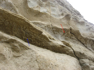
In the case of the Purisima Formation, some portions of it have more ash layers than others; Chuck Powell at the Menlo Park USGS tells me the section where this photo was taken has 13 different ash beds.

This ash bed in particular has been correlated with the Putah Tuff Member of the Tehama and Tuscan Formations of Northern California. The Putah Tuff is approximately 3.4 +/- 0.1 Ma, based on radiometric dating.

The problem with finding and utilizing tephra in the first place for dating or for tephrochronology of course is whether or not it gets preserved in the rock record. Ash forms before an eruption as bubbles form near the opening of a volcanic vent during the release of gas prior to an eruption; the magma that forms the material surrounding the gas cools and mineralizes. This mineralized material forming minute walls between gas bubbles then fragments as the eruption continues, and due to the small size (ash is classified by igneous petrologists and volcanologists as being >2mm) these fragments are then carried into the atmosphere via a 'current' of heated air before and during the eruption. Ash can stay in the atmosphere for long periods of time, and can even travel around the globe. Ash beds chemically identical to Yellowstone's Huckleberry Ridge Tuff (2.2 Ma) have been discovered in deep sea cores from the Northeastern Pacific Ocean. Since ash blows with the prevailing wind direction, and the prevailing winds in North America are westerlies, the ash apparently traveled around the earth (if anyone, e.g. Jeanette, has a reference for circumglobal ash deposition, let me know).

Typically, quieter ocean waters preserve ash better, as the ash needs to fall to the ocean surface, and settle to the sediment-water interface. High energy environments on the continental shelf rework sediment too rapidly to preserve discrete ash beds. However, there is also problem with depositing ash below storm- and fair-weather wave base: bioturbation.

Ah, those pesky critters geologists never like to pay much attention to - you know, animals. Well, in this case, geologists will probably like them even less. The problem is that below storm- and fair-weather wave base, bioturbation is insane - in some cases, like in the Purisima Formation, bioturbators effectively completely homogenize the sediment; I would estimate (based on ichnofabric index) that the sediments in these strata have bioturbated over 95% of the sediment, at least as preserved in a 6 km section of cliffs, which are 100-250' high; I'm too lazy to do the math, but that is a real shit load of sediment to churn through - and thats just in 2D - I don't even want to imagine what the actual volume of bioturbated sediment would be.

In the photograph I've posted (finally), you can see the Putah Tuff correlative ash bed. However, there's a twist - below the bed are the trace fossil Ophiomorpha nodosa, which invade sediments below the ash bed (Blue Arrow). These burrows are infilled with ash, and appear white on a brownish sandstone background. More Ophiomorpha nodosa invade the top of the ash bed, but are infilled with brownish sand(Red Arrow); again, there is beautiful contrast here with the brown filled burrows invading white ash.

In any event, those dastardly crustaceans weren't crafty enough to completely bioturbate the ash bed; the ash deposit was most likely too thick to be completely reworked. In all likelihood there is some sort of a preservational cutoff of ash thickness, although this would scale to the effectiveness of the bioturbating regime to homogenize sediment.

Fortunately, ichnofossils are extremely useful for paleoenvironmental reconstructions, so at least there is some information for geologists - not just a bunch of damn invertebrates destroying perfectly good sedimentary structures and ash layers.

P.s. I think I have a much better photo exemplifying this neat sand/ash contrast on a bioturbated contact; if I find it, I will post that as well).

Thursday, November 13, 2008

Challenging Field Localities Part I


So, I'm going to start a series of posts on this site, which will be posted periodically. This post series will concentrate on challenging and technical fossil localities which I've dealt with - in the future, I might post about odd challenges others have faced in the field.

So, for the first post, I'll begin with more or less a conclusion/addition to the last post - how the hell my friend Tim got up there, why he went up there, and why I unfortunately followed.

The above photo is a mosaic of four or five pictures I took and later merged in photostitch. You can see a sort of a ramp on the left side, and a spot with some recognizable footprints. The spot with the footprints is the location of a 6-8" wide ledge, with an overhang underneath; at the time I weighed a few more pounds than Tim, even without any field gear besides my rock hammer (which I later tossed down to the beach so I didn't have to mess with it on my slow descent).

The second photo (at left) shows why we went up there in the first place - there is, in the upper right portion of the photo, a concave upward feature, which is about as long as Tim is tall (~6 feet). That is a mysticete whale mandible, and it is in a bonebed; pieces of bones from this bed had 'rained' down onto a 5' wide bench from this bonebed. To the right, the bed dips, and about 200' north intersects with the beach, and is accessible without a 20+' climb up a precarious, dusty, crumbling cliff. If I had my own rock climbing gear, it would be really awesome to rappel down to this bonebed.

Tuesday, November 11, 2008

Awesome fieldwork picture


Here is a gratuitous field photo I took three years ago; my friend Tim is about 25 feet above the beach or so. I just thought I should post this, as it is a rather awesome picture. I also used a small sliver of this picture for my personal webpage.

Don't worry, If I recruit you for a day trip in my field area, I won't put you through this. He went up there on his own. Maybe I'll post more on scary-ass fossil localities in the future. All these ideas!

Monday, November 10, 2008

Correction...


So, I totally forgot a very important part of the walrus anatomy, which my girlfriend reminded me...

But I'm not going to tell you. Its time for you to play 'which of these is not like the others...'

What's different?

AND, more importantly, does anyone out there (I.E. any of Annalisa's ex-students) have any suggestions on how to improve the reconstruction?

If noone does, then I'll assume my artwork is 100% perfect (as it usually is).